


In 2019, Studio RAD began working with a team at Northern Michigan University to create a report with the aim of establishing a toolkit of “best practices” for development along Lake Superior’s south shore. Studio RAD provided consulting services along with the graphical elements for project workshops and for the final report document that was published in December, 2020.
View the digital version of the report here: Coastlines & People Digital Publication
View the project website here: Coastlines & People Website
The Coastlines & People project was funded by the National Science Foundation. Studio RAD worked alongside the project team at Northern Michigan University to engage local and regional experts and stakeholders through a series of three workshops hosted by NMU.
Timeline of important events in the history of Lake Superior’s south shore.
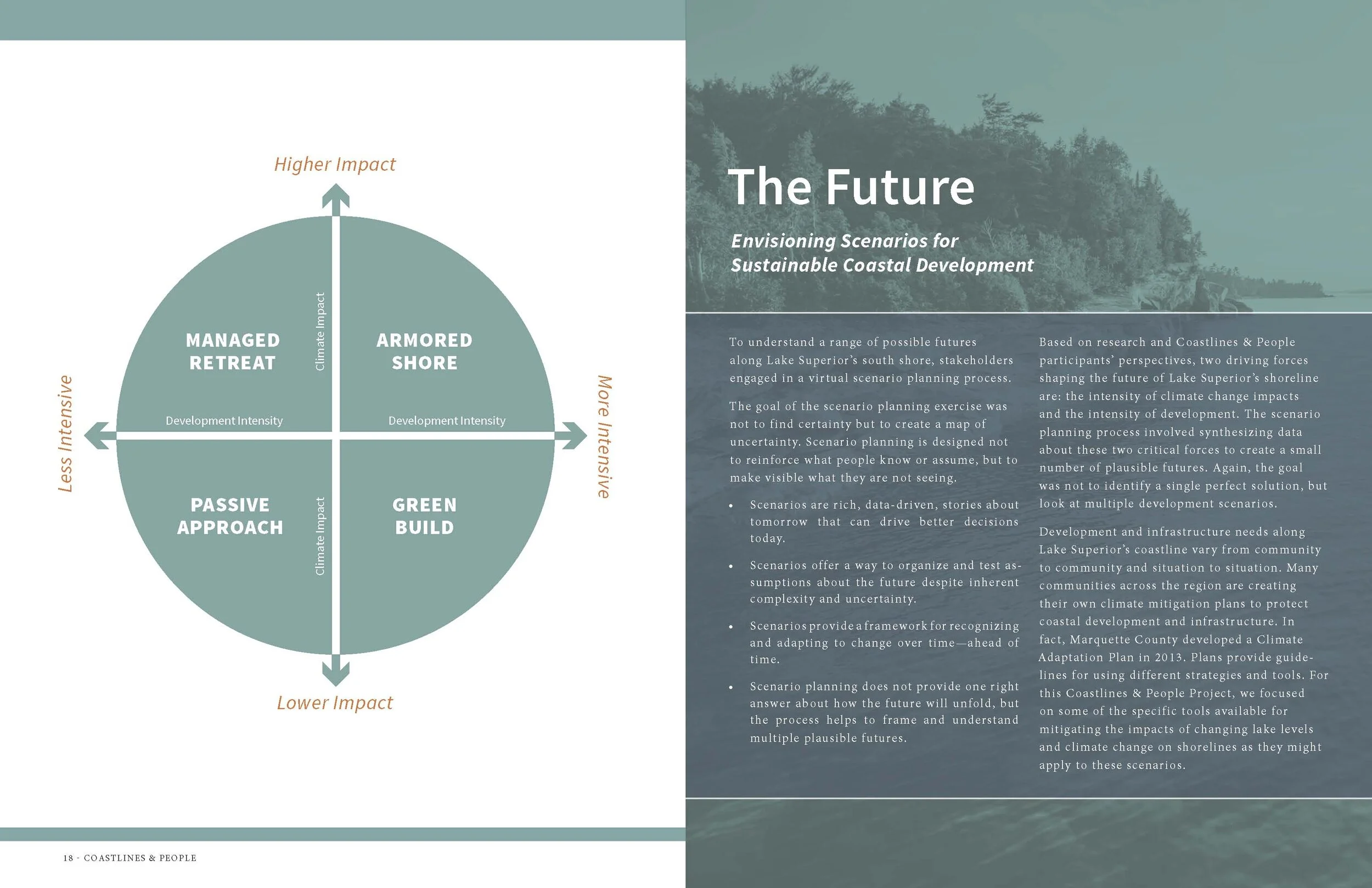
Based on research and Coastlines & People participants’ perspectives, two driving forces shaping the future of Lake Superior’s shoreline are: the intensity of climate change impacts and the intensity of development. The scenario planning process involved synthesizing data about these two critical forces to create a small number of plausible futures. Again, the goal was not to identify a single perfect solution, but look at multiple development scenarios.
While it is easy to talk in the abstract about priorities for the built or unbuilt environment, those priorities can get lost when the development process starts. Our goal with The Future phase of this project was to use case studies to understand how elements added or subtracted from a site might affect the resiliency of coastal communities, and to provide visualizations to show immediate and long-term priorities expressed by workshop participants.
To help ground different scenarios of coastal development in possible realities, we imagined three test sites that represent archetypal conditions found along the southern coast of Lake Superior: Post-Industrial River, Downtown District, and Transportation and Critical Infrastructure. These three sites help to illustrate how different locations can manifest combinations of the development scenarios.
The goal of these visualizations is not to create plans for any specific community. Rather, the goal is to use information gleaned from regional stakeholders at the Coastline & People workshops to creatively envision what resilient development might look like along Lake Superior’s southern shore.
The Post-Industrial River Archetype imagines the site of a decommissioned industrial plant that is located at the intersection of a river and the shoreline. The area incorporates several different landscape typologies including forests, beaches and wetlands. It is visually removed from a nearby developed urban neighborhood but maintains strong transportation linkages.
The Modern Manufacturing District (MMD) would consist of an anchor tenant—businesses that are well established within a field, such as technology and manufacturing—as well as smaller scaled companies such as start-ups, business incubators or small-scale manufacturers and artisans.
Modern Manufacturing District Viewed from Beach and Dune Restoration Area.
Modern Manufacturing District Viewed from Mixed-Use Link.
The Downtown District imagines a location that is defined primarily by being in the downtown of an existing waterfront community. It has evolved over time through iterations of a community’s development and is at the current time underutilized to its best potential. In our imaginary site there is an existing network of armored infrastructure and piers that while not ideally constructed, do increase and extend the city’s shoreline into the lake. These structures represent the vestiges of industry from a bygone era. In many cases because of current laws prohibiting development in Lake Superior they wouldn’t be allowed to be built today.
In our scenario we imagine a combination of enhancing the existing armored shore in a way that provides cohesion to the disparate existing piers and structures. Using green building methodology and prioritizing public access, space can be carved out for commercial and residential use that mutually benefit from the expanse of public spaces.
View of Outdoor Ampitheater on Adaptive Reuse Hardscape Plaza Pier.
View of Adaptive Reuse Botanical Pier.
View of Beach Restoration with Public Green & Hardscape Plaza Pier Beyond.
The Transportation and Critical Infrastructure archetype represents the many locales along the south shore of Lake Superior that are relatively undeveloped but contain thoroughfares and critical services. This proximity to the shoreline has caused a cycle of maintenance and repair that has become unsustainable for its municipality.
The cycle of destruction and repair caused by changing shoreline conditions has led decision-makers to conclude that doing nothing—a passive approach—would not be cost-effective.
In this case, the community may prioritize a strategy of managed retreat to allow natural habitats to reestablish themselves, and to provide a buffer between developed areas and the lake.
View of Recreational & Educational Trailhead.
View of Beach & Dune Restoration Area with Wetland Area and Educational Building Beyond.